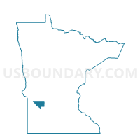
Maynard Voting District, Chippewa County, Minnesota
About
Outline

Summary
| Unique Area Identifier | 601482 |
| Name | Maynard Voting District |
| County | Chippewa County |
| State | Minnesota |
| Area (square miles) | 0.65 |
| Land Area (square miles) | 0.65 |
| Water Area (square miles) | 0.00 |
| % of Land Area | 99.94 |
| % of Water Area | 0.06 |
| Latitude of the Internal Point | 44.90416350 |
| Longtitude of the Internal Point | -95.46856290 |
Maps


Graphs
Select a template below for downloading or customizing gragh for Maynard Voting District, Chippewa County, Minnesota